
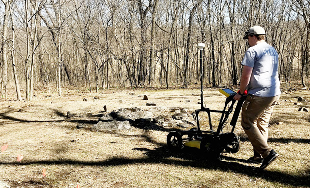
Team members from Missouri Department of Natural Resources and Missouri State Parks used GPR to locate and collect data on several unmarked graves.
The Missouri Department of Natural Resources usually uses ground-penetrating radar, or GPR, for finding waterlines and leaks or buried tanks. However, the department put that technology to another use at Nathan and Olive Boone Homestead State Historic Site, where several unmarked graves in both cemeteries on the property were discovered.
“During my new employee orientation with the Missouri Department of Natural Resources’ Division of State Parks, I had the opportunity to tour the different divisions within the agency,” said Mike Busekrus, site superintendent. “When I visited the Environmental Emergency Response team, I saw the ground-penetrating radar. I thought that’s something I should keep in mind, but I wasn’t sure why. I didn’t know when or why I’d need it, but I tucked that information away.”
Busekrus is charged with managing the state historic site near Ash Grove, Missouri. The site includes almost 400 acres of Nathan and Olive Boone’s original homestead, remnants of outbuildings and two separate cemeteries; one for the Boone family and one for the enslaved people who worked on the farm.
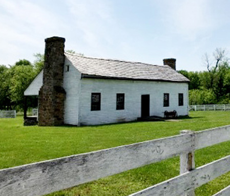
Nathan and Olive Boon’s homestead located near Ash Grove.
“In an effort to better understand the lives of the enslaved who lived here on the Boone Homestead, we need to better understand the most visible reminder of their presence, the African American Cemetery,” Busekrus said. “When the cemetery was first located by archeologists in the 1990s, its exact borders were unknown.”
Sadly, unmarked graves are common in older cemeteries, especially ones more than 100 years old. Often, grave records are lost, vague or incomplete. Sometimes there isn’t even surface expression of the grave, so the burial location isn’t seen from aboveground. The challenge is how to explore the subsurface without disturbing the soil or the graves.
Busekrus, intent on learning more about the history of the site, recalled the department’s Environmental Emergency Response team using GPR. GPR is a geophysical method often used in archaeological and forensic investigations and even grave detection. When the African American cemetery was first located, the use of ground-penetrating technology in archeological work was still limited.
According to Rachel Campbell, an archaeologist with Missouri State Parks, GPR has a transmitter that sends out energy waves, then the receiver records the amount of time and strength needed for the return of the reflected signal. The density of any object encountered will uniquely reflect, refract and distribute the signal, which the receiver detects and records.
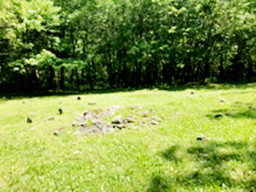
Pictured is the enslaved cemetery at Nathan and Olive Boone’s homestead where the department recently located 11 more unmarked graves
“GPR records variation in composition of ground material as the signals travel differently through various soil types,” Campbell said. “Changes and mixing of soils are picked up by the machinery due to the modification of density in the soil that occurs during a burial. GPR is a wonderful technology to use for archaeological research as it’s noninvasive, and the radar doesn’t cause any harm to the burials or other subsurface features or artifacts that may be present.”
Busekrus said it is similar to a fish finder but without water. A fish finder locates fish in the water by detecting reflected pulses of sound energy. A fish finder displays measurements of reflected sound, allowing the operator to locate schools of fish, underwater debris and the bottom of the body of water. Likewise, if someone uses GPR on a regular basis, they become familiar with the readings and can decipher tree roots and other ground disturbances from items put there by man.
With the equipment already in place, no outside expenses would be incurred if they used it to check for more unmarked graves. So, Busekrus jumped on the idea and ran with it, reaching out to the department’s Environmental Emergency Response team in charge of the GPR.
A group of seven, including Busekrus, Campbell and members from the department’s Environmental Emergency Response team, spent two days at the historic site in March 2022. A 30-foot-wide perimeter was cleared around the existing boundary of the African American Cemetery. To be sure they covered the entire cemetery where there was a possibility of a gravesite, the crew laid out a 2-foot grid, collecting data along each grid line.
“This was a relatively quick process, and it was done all in-house,” Busekrus said. “It took our team a day and a half to collect the data for the African American Cemetery. The graves are mostly unmarked in the enslaved cemetery, with only two bearing faint inscriptions: Moses Boone and Preston Boone. Since there are no records of the burials in the cemetery, the GPR data is our best tool to understand its size and significance.”
During the study, the team discovered at least eight more burials in the enslaved cemetery, two of these burials were outside of the previously known cemetery boundary. The team then set their sights on the Boone Cemetery, where they located five more unmarked graves.
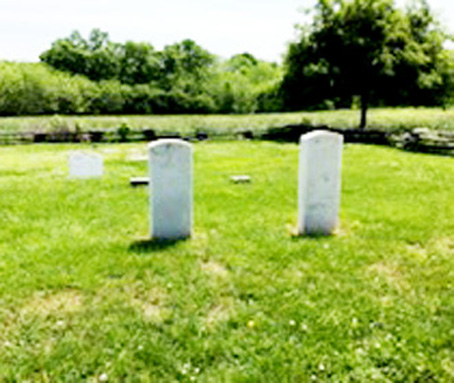
In the cemetery, Nathan and Olive Boone’s graves are among the few of the known locations.
“My hope is to continue working with Mike to produce a detailed map of the cemeteries and the anomalies seen during the survey,” Campbell said. “This would be used for a greater interpretation of the site and the lives of the enslaved people who lived there. We also hope to use this study as a jumping-off point for further geophysical studies at the site, expanding our knowledge of the larger landscape and use of the homestead.”
With the new graves discovered, the size of the African American cemetery nearly doubled, going from 11 known graves to 19. In the Boone Cemetery, there are now 20 known graves, many of which were children. Nathan and Olive Boone, along with Olive’s 104-year-old mother, are also buried there.
During the two-day study, the team also used the equipment in another area in an unsuccessful attempt to locate the remains of the enslaved quarters.
“We knew it was a bit of a longshot, but with the technology already on-site, it was worth a try,” Busekrus said.
In 1991, the Missouri Department of Natural Resources acquired the homestead, outbuildings and 400 acres. The historic site offers tours of the property, and Busekrus works to tell an accurate history of the life on the homestead.
“This work helps us to have a better understanding of how life unfolded here in the 19th century; it gives us a starting point to better tell the stories of the lives of the individuals enslaved on the homestead,” Busekrus said. “As history continues to reveal itself, we will continue to tell the story.”
For more information on state parks and historic sites, visit mostateparks.com. Missouri State Parks is a division of the Missouri Department of Natural Resources.

Facebook Comments